This post first appeared on Free Technology for Teachers.
Maps are a great way for students to navigate their understanding of different topics. While it is useful for geography (of course), students can also use mapping to increase their understanding of a story in English, a lesson in History, studies in Ecology, and more. Here are three FREE tools that allow students and teachers to create interactive maps, and they don’t require a login!
Zee Maps
Zee Maps allows users to create interactive maps online for free (or an added fee for additional features). At the free level, it does not require a login. Users can import data from an existing spreadsheet or manually input information as they build their map. Users can add multimedia (images, video, or audio) in their markers and color code specific regions (zip codes, states, countries, etc). Another cool feature is that users can crowd-source information from their followers.
NatGeo Mapmaker Interactive
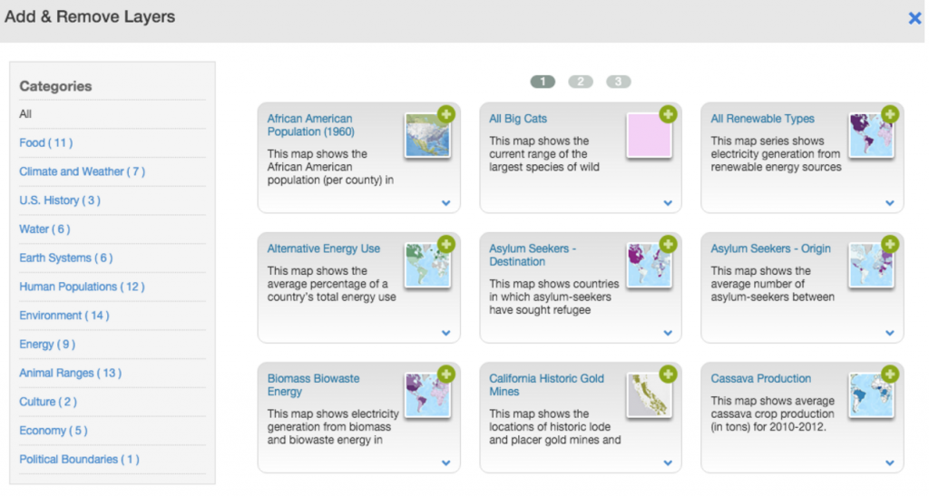
NatGeo has introduced a really cool, interactive map maker to the market. In addition to the traditional mapping tools of markers and shapes/colors, users can use a variety of base maps (political, street lines, topographical, and more) and then overlay various layers such as the distribution of endangered animals, climate, energy production, etc. This is a great way to bring mapping into broader realms of study. It is important to note that while users can create and print maps without sharing any personal information, if they want to share a map or save it to edit later, they will need an email address.
Scribble Maps
Scribble maps works both on the web and on mobile devices. Just as the name implies, the interface allows you to create maps by drawing. You can import map data from a variety of sources, including Google Maps, Open Street, and Night Sky; yep, you can even have your students map the heavens! You can insert color shapes or markers, text, and scribble on your map to create various lines and shapes. Users do not need to create an account to save their work or embed it online. In fact, you can even protect a map with a password.
These are only three resources for creating online maps. They allow students to delve more deeply into the world around them or, in the case of Scribble Maps, the skies.
Want to learn more? Join us for over 18 different workshops this summer in Atlanta, Baltimore, Boca Raton, Boston, Chicago, Los Angeles, or San Francisco!


